01 · Where the sun is
Mean longitude, mean anomaly and the equation of center give the apparent longitude ; with the obliquity that fixes declination and right ascension — the Astronomical Almanac’s low-precision solar series, good to ~0.01°.
Playground · research instrument
How much sun does that spot actually get? Sunrise, solar noon, sunset and golden hour to the minute; how long a shadow anything casts, and which way it points; how many hours of direct sun a garden gets once trees and buildings are in the way; and what a solar array on that roof would make in a day. Any place, any date, worked out in your browser — the astronomy is the same series that draws our globe's day/night terminator.
Independent research instrument — not claimed as MakerPortal shipped product code. Methods, equations, assumptions, and limitations are disclosed so you can inspect what the page does and does not establish.
The answer
The sun is up 11h 21m today — 7:02 AM to 6:23 PM, highest at 12:43 PM, 42° above the horizon.
With an open sky this spot gets 11h 13m of direct sun: full sun.
Everything runs in your browser — no location is sent anywhere.
Your browser will ask next. The coordinates are rounded to about a kilometre, used only to solve the sun, and never leave this page — there is no server to send them to.
Sky dome · looking up (east mirrored left)
2026-10-10 · faint arcs = June / December solstices
Ground plan · north up, east right
—
10:00
Solved day
Shadow ratio 1.76 × height · civil dawn/dusk and golden hour solved live
What that much sun is actually worth
Everything above is geometry: where the sun is. This turns it into energy — how many watts an array of a given size and angle collects through the day, how many kilowatt-hours that adds up to, and the one fixed angle that collects the most over a whole year at this latitude. Clear sky only:no cloud, no terrain, no shading, so read every number as the ceiling a real installation works down from. The best annual angle is steeper than the best summer angle — it buys winter back at the cost of a little June, so switching to it can lower today's figure while raising the year's.
Clear-sky output through the day
solid = your angle · dashed = best ANNUAL angle
on the panel 690 W/m² · beam 787 W/m² · horizontal 484 W/m² · air mass 2.02 · cell 42 °C · glass −2.2% · heat −7.6% · peak at 12:40 PM
01 · Where the sun is
Mean longitude, mean anomaly and the equation of center give the apparent longitude ; with the obliquity that fixes declination and right ascension — the Astronomical Almanac’s low-precision solar series, good to ~0.01°.
02 · Over your head
Elevation comes from your latitude , the sun’s declination and the longitude gap . Azimuth is the sun vector against your local east/north/up basis — no hour-angle sign conventions to trip on.
03 · When it crosses
Sunrise, sunset, civil twilight and golden hour are all the same problem: find when elevation crosses a threshold. The solver scans the local day and bisects each crossing to sub-second — so polar day and night fall out as “no crossing”, not an error.
04 · Shadow on the ground
Shadow length for an object of height , pointing away from the sun’s azimuth. The shadow ratio is the site-independent version: 1 at 45° elevation, 5.7 at 10°.
Sunrise here uses the standard −0.833° horizon: the sun’s upper limb touching a flat sea-level horizon with standard atmospheric refraction. Apps that know your elevation or model terrain can shift the time by a minute or two; so can your actual horizon, by much more. The geometry is the easy part — your hills are the real answer.
Shadow ratio is shadow length per unit of object height: 1 / tan(sun elevation). At 45° elevation the ratio is 1 (a 6 ft pole casts a 6 ft shadow). At 10° elevation it is 5.7 — winter-morning shadows run several times the height of the object casting them.
Two reasons stacked: your longitude is usually offset from the center of your time zone (15° of longitude = a full hour), and the equation of time — the difference between a sundial and clock time caused by Earth’s tilted axis and elliptical orbit — swings between about −14 and +16 minutes across the year.
The solver reports the truth: on midsummer days the sun never dips below the horizon (no sunrise crossing — polar day) and in winter it never rises (polar night). The sun-path arc simply stays inside or outside the horizon ring, and the day length card says which.
For geometry, yes: azimuth, elevation, shadow length and direction are exact for a flat horizon. Siting decisions should add your real horizon (trees, buildings, terrain) and local weather — this calculator supplies the sky, not the obstacles.
Shareable still
This 16:9 frame is rendered from the real browser instrument above. It is the page's canonical preview for image search, link unfurls, and posts that need to show what the tool actually does.
Download 1280 × 720 JPEG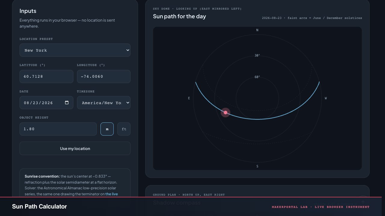
Continue the experiment